Where WAS
BASTILLE?
|
|
|
Not exactly where you'd expect - that is, at what is today the Place de la Bastille. The main fortress was slightly west of that square, with walls and courtyards around it. The whole complex was right at the edge of Paris and the site of the current Place de La Bastille was largely occupied by a bastion - a pointed defensive structure which jutted out into the Faubourg St. Antoine, a suburb of Paris. If you walk east from one side of the Place de la Bastille to the other, you are walking between what was once Paris and what was once just outside it. 
Approximate match of the Bastille complex's location to modern streetsIf you're visiting Paris and want to get a frisson (that is, a cheap thrill) by tracing its exact location, things get complicated. Colored pavestones mark part of the old outline of the main castle, but there's more to it:
Bearing in mind that the Bastille was originally a defensive fortress built into the city walls, you can also envision the old battlements extending north and south from the main castle, curving inward as they progress.  "The Ghost of the Bastille" Viewed from the rue St. Antoine, which once veered off to the left at the outer walls of the Bastille, and on around it to the St. Antoine Gate. Part of the church at right still stands; today's Place de la Bastille is behind the fortress; the Rue de la Bastille is just to the left of this picture, where the outer walls end (the white buildings at left hide it, and would have hidden, in fact overrun, half of the Bastille itself, had they been there); the St. Antoine Gate once stood just beyond the rue de la Bastille. By (or more probably ordered by) Payot, the entrepreneur who directed the castle's demolition
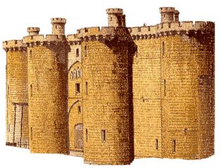
About the image at the top: The 'logo' for this site is taken from one of many drawings that show the Bastille from outside the city walls. This is the eastern side, which once faced the bastion - that is, what today is the Place de la Bastille. The arcade in the middle was once both the entrance to Paris (the Porte St. Antoine) and to the main castle. But by the eighteenth century it had been walled up, and the entrance to the main building was at the southern end of the building - that is, just to the right of the tower leftmost (farthest from the viewer) in this picture. The Porte St. Antoine was moved outside the Bastille entirely, past the rightmost tower in this picture. |

copyright 2005 Jim Chevallier.
Please do not reproduce, extract or post elsewhere without prior permission.
Looking for a gift?
How about a Welcome to the Bastille tote bag:
 or mug:
 ?
? Visit le Shop.
Questions? Comments? Corrections? Write: jimchev@chezjim.com
the Bastille |
Books |